Val d'Orcia, Tuscany - Italy

Image|Link

Introduction:


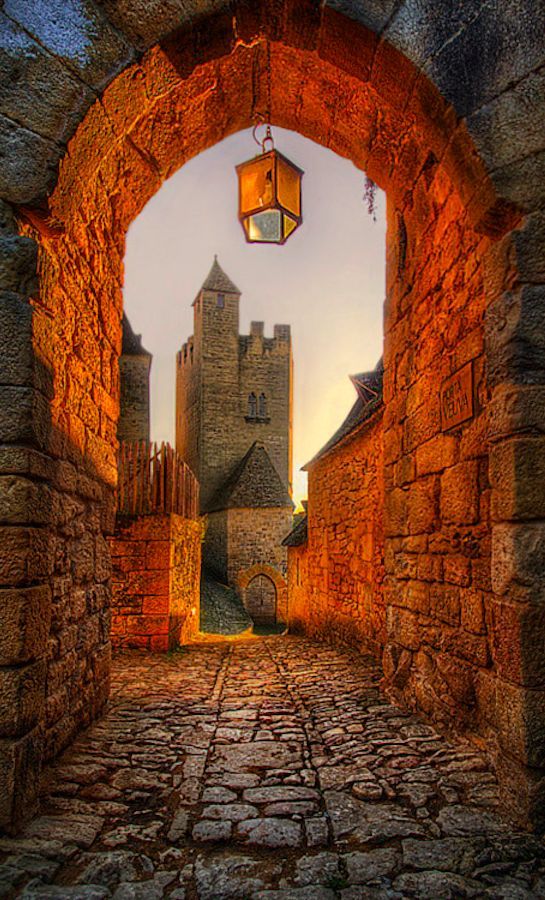
The Val d’Orcia, or Valdorcia, is a region of Tuscany, central Italy, which extends from the hills south of Siena to Monte Amiata. It is characterised by gentle, carefully cultivated hills occasionally broken by gullies and by picturesque towns and villages such as Pienza.


Image|Link

Facts:

Medieval castles, sunny rolling hills, isolated hilltop towns, charming farmhouses and isolated rural homes, avenues of cypresses, rows of vineyards, olive groves, and golden wheat fields are just some of the elements of the fantastic and harmonious landscapes of Valdorcia.

Val d'Orcia, Tuscany - Italy

Image|Link

The Val d’Orcia is characterised by gentle, carefully-cultivated hills occasionally broken by gullies and by picturesque towns and villages such as Pienza (rebuilt as an “ideal town” in the 15th century under the patronage of Pope Pius II), Radicofani (home to the notorious brigand-hero Ghino di Tacco) and Montalcino

Article Sources : Link|Link|Link


Orcia, Tuscany - Italy

Valugan Boulder Beach, Philippines

 Image|Link

Introduction:

Valugan or east in the local language of the Ivatan, is where the bay got its name because it is located on the east side of Batanes. Valugan Bay is a boulder beach perfect for picture taking and resting while watching the waves touch the big rocks. You can even try closing your eyes and hear what the winds has got to say to you.

Valugan Boulder Beach, Philippines

 Image|Link

Facts:

There is no white sand here. Instead, countless boulders fill Valugan Beach, creating an incredible landscape framed by almost vertical cliffs and rolling hill.


Valugan Boulder Beach, Philippines

 Image|Link

Get in :

Philippine Airlines (PAL Express) and Skyjet fly to Basco, the Batanes capital. From the airport or your inn, Valugan Beach can be reached by tricycle. North Batan Tour usually costs P1000 per tricycle (good for 2 pax).

Article Sources : Link|Link|Link

Valugan Boulder Beach, Philippines

Castle De Haar, near Haarzuilens, Utrecht, The Netherlands
 Image|Link

Introduction:

Castle De Haar is located near Haarzuilens, in the province of Utrecht in the Netherlands. The current buildings, all built upon the original castle, date from 1892 and are the work of Dutch architect P.J.H. Cuypers, in a Neo-Gothic restoration project funded by the Rothschild family.

Castle De Haar, near Haarzuilens, Utrecht, The Netherlands
 Image|Link

Facts:

Haarzuilens is a former small village in the Dutch province of Utrecht. It is a part of the municipality of Utrecht, and lies about 8 km west of Utrecht. It was a separate municipality until 1954, when it was joined to the municipality of Vleuten.

Castle De Haar, near Haarzuilens, Utrecht, The Netherlands
Image|Link

Get in:

he bus station is located next to the train station. International and some regional buses depart from the western side of the train station , while most regional and all city buses depart from Busstation CS Centrumzijde at the east side of the train station. Regional buses are much slower than the trains. U-OV provides public transport services in the city of Utrecht and the region around. Some other companies run long distance connections

Article Sources : Link|Link|Link


Castle De Haar, near Haarzuilens, Utrecht, The Netherlands

Dartmoor in Devon
 Image|Link

Introduction:

Dartmoor is an area of moorland in south Devon, England. Protected by National Park status as Dartmoor National Park, it covers 954 square kilometres (368 sq mi).The granite which forms the uplands dates from the Carboniferous Period of geological history.

Dartmoor in Devon
 Image|Link

Facts:

With the largest concentration of Bronze Age remains in the UK, there is plenty for the modern antiquarian to discover on Dartmoor. But if you want something a little more exciting than Bronze Age barrows and spectacular scenery, there are plenty of outdoor activities to get your pulse racing.


Dartmoor in Devon

 Image|Link

Get in:

Exeter has two main train stations, St. Davids (where most long-distance services call,) and Central. Central, unsurprisingly, is closer to the centre of town, but the two are within a short walk of one another.


Article Sources : Link|Link|Link

Dartmoor in Devon

The Moeraki Boulders (Dragon Eggs) In Koekohe Beach, New Zealand

 Image|Link

Introduction:

The Moeraki Boulders are unusually large and spherical boulders lying along a stretch of Koekohe Beach on the wave-cut Otago coast of New Zealand between Moeraki and Hampden. They occur scattered either as isolated or clusters of boulders within a stretch of beach where they have been protected in a scientific reserve.


 Image|Link

Facts:

Some are isolated but may occur in clusters. That they are here is the result of three things – erosion, concretion and time. First the waves, inexorable and patient, have pounded the local bedrock for countless millennia. The mudstone on the beach – rock which was originally mud and clay – is slowly but surely eroded.


 Image|Link

The story according to scentists is not quite so exciting. The boulders have come from the mudstone cliffs behind where they eroded away and have been given their round shape by erosion from the surf.

Article Sources : Link|Link|Link

The Moeraki Boulders (Dragon Eggs) In Koekohe Beach, New Zealand

wat arun

 Image|Link

Introduction:

Wat Arun Ratchawararam Ratchawaramahawihan or Wat Arun  is a Buddhist temple (wat) in Bangkok Yai district of Bangkok, Thailand, on the Thonburi west bank of the Chao Phraya River. The temple derives its name from the Hindu god Aruna.


 Image|Link

Facts:

This Wat or Buddhist temple is an architectural representation of Mount Meru, the center of the world in Buddhist cosmology. In the mythology of Tibetan Buddhism, Mount Meru is a place that simultaneously represents the center of the universe and the single-pointedness of mind sought by adepts

wat arun
 Image|Link

Get in:

Finding a place to go online is not an easy task in Thonburi. It is mostly a residential neighbourhood and most Thais have an internet connection at home. You might want to ask around with the locals. There are some Internet cafes along Phran Nok Road, such as The Corner CoffeeShop & Internet near the Wang Lang area.


Article Sources : Link|Link|Link

Wat arun

Wat ratchanadda

 Image|Link

Introduction:

Wat Ratchanaddaram  is a buddhist temple (wat) located at the intersection between Ratchadamnoen Klang and Maha Chai Road, in Phra Nakhon district, Bangkok. Meaning Royal Niece, the temple was built to the order of King Nangklao  for the princess granddaughter, Somanass Waddhanawathy  in 1846.

Wat ratchanadda

 Image|Link

Facts:

Construction was started in the reign of Rama III in the 19th century but was only recently completed due to the complexity of its design. There are five towers of varying sizes, topped by huge iron spikes. The many columns create a labyrinth. The central tower has steps that lead to shrine at the top. The amulet market behind the temple is famous.


 Image|Link

The prasat itself is like five concentric square towers, each consecutively taller than the other. The outer, middle and center towers are capped by cast iron spires, which gives the temple its name.


Article Sources : Link|Link|Link


Wat ratchanadda

+